All Resources
Agenor Linea on Europa
Agenor Linea is unique in that it is similar in width and length to dark bands seen in the northern hemisphere, but it is bright in color rather than dark.
Original Caption - March 26, 1998
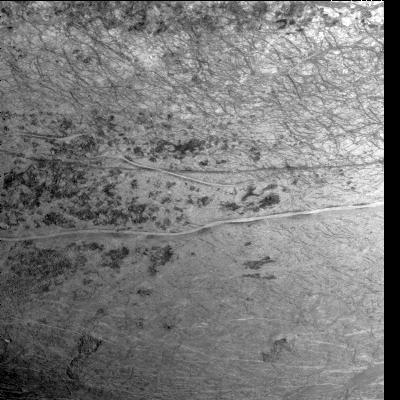
This image of Europa's southern hemisphere was obtained by the solid state imaging (CCD) system on board NASA's Galileo spacecraft during its sixth orbit of Jupiter.
The upper portion of the image shows the southern extent of the "wedges" region, an area that has undergone extensive disruption. South of the wedges, part of Agenor Linea (nearly 1,000 kilometers in length) is also visible.
Agenor Linea is unique in that it is similar in width and length to the dark bands seen in the northern hemisphere, but it is bright in color rather than dark.
North is to the top of the picture and the sun illuminates the surface from the right. The image, centered at 40 degrees south latitude and 210 west longitude, covers an area approximately 675 by 675 kilometers. The finest details that can discerned in this picture are about 3.3 kilometers across. The images were taken on Feb 20, 1997 at 12 hours, 55 minutes, 34 seconds Universal Time when the spacecraft was at a range of 81,707 kilometers.