All Resources
Europa Compared to Earth
A series of five images that compare terrain on Europa to the San Francisco Bay area in Calfornia for scale.
Image 1
157 by 244 miles (252 by 393 kilometers)

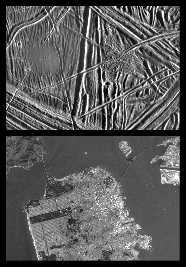
This is the first in a series of products that compare images at increasing resolutions of various areas on Jupiter's icy moon Europa (top frame) to the same location on Earth, the San Francisco Bay area of California (bottom frame). Both images show areas of roughly equal size, 157 by 244 miles (252 by 393 kilometers), and resolution, 690 yards (630 meters ). This means that the smallest identifiable feature is less than a mile across (2 pixels wide). North is to the top of the picture.
The Sun illumination from the right in the Europa image reveals several ridges crossing the scene, plateaus commonly several miles (10 km) across, and patches of smooth, low-lying darker materials. No prominent impact craters are visible, indicating the surface in this location is not geologically ancient. Some ridges have gaps, and subtle textural differences in these areas indicate that missing ridge segments probably were swept away by volcanic flows. The flow deposits are probably composed mainly of water ice, the chief constituent of the surface of Europa.
The Earth based image (lower frame) covers an area stretching from San Francisco Bay (top left) to the Nevada border (top right) and from Mono Lake in (top center) to the Mojave Desert (bottom right). Other predominant geographic features include the snow capped Sierra Nevada Mountains and California's Great Central Valley (center frame).
The Europa image was obtained from a range of 39,028 miles (62,089 kilometers) by the Solid State Imaging (CCD) system aboard NASA's Galileo spacecraft on December 19th, 1996 (Universal Time). The San Francisco Bay area image, from the NOAA satellite's Advanced Very High Resolution Radiometer (AVHRR) instrument, has been reprocessed to roughly match Galileo's resolution so as to offer a sense of the size of the features visible on Europa's surface.
Image 2
62 by 87 miles (100 by 140 kilometers)

This is the second in a series of five products at increasing resolutions that compare images of various areas on Jupiter's icy moon Europa (top frame) to the same location on Earth, the San Francisco Bay area of California (bottom frame). Both images show areas of equal size, 62 by 87 miles (100 by 140 kilometers), and resolution, 200 yards (180 meters). This means that the smallest visible object is about a quarter of a mile across. North is to the top of the picture.
This complex terrain shows an area centered at 8 degrees north latitude, 275.4 degrees west longitude, in the trailing hemisphere. As Europa moves in its orbit around Jupiter, the trailing hemisphere is the portion which is always on the moon's backside opposite to its direction of motion. The complex ridge crossing the picture in the upper left corner is part of a feature that can be traced hundreds of miles across the surface of Europa, extending beyond the edge of the picture. The upper right part of the picture shows terrain that has been disrupted by an unknown process, superficially resembling blocks of sea ice during a springtime thaw. Also visible are semicircular mounds surrounded by shallow depressions. These might represent the intrusion of material punching through the surface from below and partial melting of Europa's icy crust.
In the San Francisco Bay area image, the level of detail is such that jigsaw puzzle like patterns of agricultural fields can be seen in the upper right corner and some levels of physical relief can be detected in the coastal mountain ranges. Also discernible at this resolution are the vast urban areas along the shores of the bay. Alcatraz Island appears as a tiny speck at center frame.
The Europa image was obtained from a range of 11,100 miles (17,900 kilometers) by the Solid State Imaging (CCD) system aboard NASA's Galileo spacecraft on February 20th, 1997 (Universal Time). The San Francisco Bay area image, from the LandSat Thematic Mapper, has been reprocessed to match Galileo's resolution so as to offer a sense of the size of the features visible on Europa's surface.
Image 3
21 by 26 miles (34 by 42 kilometers)

This is the third in a series of five products at increasing resolutions that compare images of various areas on Jupiter's moon Europa (top frame) to the same location on Earth, the San Francisco Bay area of California (bottom frame). Both images show areas of equal size, 21 by 26 miles (34 by 42 kilometers), and resolution, 59 yards (54 meters). North is to the top of the picture.
This high resolution image shows Europa's ice-rich crust with crustal plates ranging up to 8 miles (13 kilometers) across, which have been broken apart and "rafted" into new positions, superficially resembling the disruption of pack-ice on polar seas during spring thaws on Earth. The size and geometry of these features suggest that motion was enabled by ice-crusted water or soft ice close to the surface at the time of disruption. This Europa image is centered at 9.4 degrees north latitude, 274 degrees west longitude,
The San Francisco Bay portion of this image pair helps to give the viewer some sense of scale as it relates to the size of the Europa "ice rafts." Look, for example, at the cratered "ice raft" in the lower left hand portion of the Europa image. Compare that to such features in the Bay area image as Treasure Island Naval Station, (center frame) and the San Francisco International Airport (bottom right). Also in this image, at 54 meters resolution, structural features such as the Golden Gate Bridge and the Bay Bridge are clearly visible.
The Europa image was obtained from a range of 3,320 miles (5,340 kilometers) by the Solid State Imaging (CCD) system aboard NASA's Galileo spacecraft on February 20th, 1997 (Universal Time). The San Francisco Bay area image, from the LandSat Thematic Mapper, has been reprocessed to match Galileo's resolution so as to offer a sense of the size of the features visible on Europa's surface.
Image 4
11 by 30 miles (17 by 49 kilometers)

This is the fourth in a series of five products at increasing resolutions that compare images of various areas on Jupiter's icy moon Europa (left frame) to the same location on Earth, the San Francisco Bay area of California (right frame). Both images show areas of equal size, 11 by 30 miles (17 by 49 kilometers), and resolution, 100 feet (30 meters). North is to the top of the picture.
The frame on the left is a mosaic of two images of Europa and shows the surface to be structurally complex. The Sun illuminates the scene from the east, revealing complex overlapping ridges and fractures in the upper and lower portions of the frame, and rugged, more chaotic terrain in the center. Lateral faulting is revealed where ridges show offsets along their lengths (upper left of the frame). Missing ridge segments indicate obliteration of pre-existing materials and emplacement of new terrain (center of the frame).
The surface of San Francisco rivals that of Europa. In this 30 meter resolution comparison image, the complex pattern of city streets is clearly visible as are the many piers that line the water front district (upper right). This Bay area scene is also illuminated from the east. Notice the shadow of the Bay Bridge on the surface of the water as it makes its way to Oakland and the east bay. In the upper left corner, a ship can be seen making its way to the mouth of the bay.
The Europa image was obtained from a range of 2,119 miles (3,410 kilometers) by the Solid State Imaging (CCD) system aboard NASA's Galileo spacecraft on December 19th, 1996 (Universal Time). The San Francisco Bay area image, from the LandSat Thematic Mapper, has been reprocessed to match Galileo's resolution so as to offer a sense of the size of the features visible on Europa's surface.
Image 5
8 by 11 miles (13 by 18 kilometers)

This is the fifth in a series of products at increasing resolutions that compare images of various areas on Jupiter's moon Europa (top frame) to the same location on Earth, the San Francisco Bay area of California (bottom frame). Both images show areas of equal size, 8 by 11 miles (13 by 18 kilometers), and resolution, 28 yards (26 meters). North is to the top of the picture.
In this close-up view of Europa's icy surface, a flat smooth area about 2 miles (3.2 kilometers) across is seen in the left part of the picture. This area resulted from flooding by a fluid which erupted onto the surface and buried sets of ridges and grooves. The smooth area contrasts with a distinctly rugged patch of terrain farther east, to the right of the prominent ridge system running down the middle of the picture. Eruptions of material onto the surface, crustal disruption, and the formation of complex networks of folded and faulted ridges show that significant energy was available in the interior of Europa. The Sun illuminates the scene from the east (right).
The San Francisco Bay area image helps to give a sense of scale to the predominant features in the Europa image above. Both the "flat smooth area" and the contrasting "rugged patch" are sufficiently large to cover all of downtown San Francisco. The Golden Gate Bridge, if on Europa's surface, would be long enough to span each of those features as well.
The Europa image was obtained from a range of 1,600 miles (2,500 kilometers) by the Solid State Imaging (CCD) system aboard NASA's Galileo spacecraft on December 19th, 1996 (Universal Time). The San Francisco Bay area image, from the LandSat Thematic Mapper, has been reprocessed to match Galileo's resolution so as to offer a sense of the size of the features visible on Europa's surface.