All Resources
Europa: Sea Salts or Battery Acid
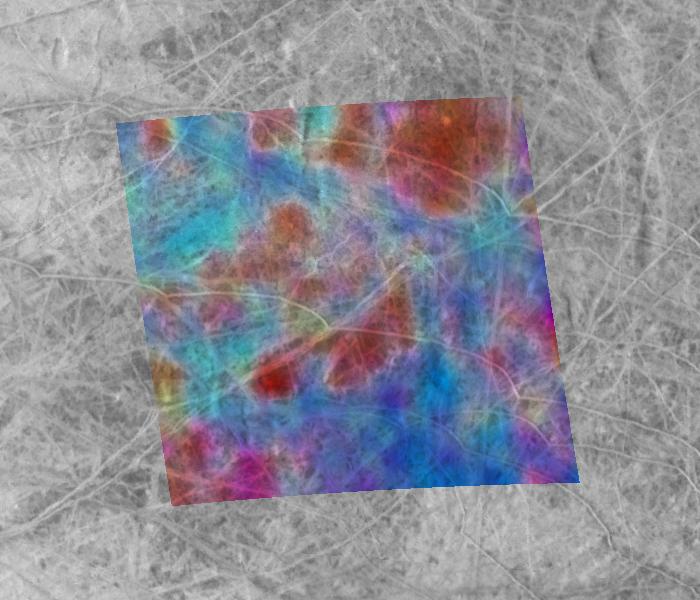
This composite image of the Jupiter-facing hemisphere of Europa was obtained on Nov. 25, 1999 by two instruments onboard NASA's Galileo spacecraft. The global black-and-white view, by the spacecraft's camera, provides the highest resolution view ever obtained of this side of Europa. The superimposed false-color image, obtained by Galileo's near-infrared mapping spectrometer instrument, reveals the presence of materials with differing compositions on Europa's surface.
In this image, blue areas represent the cleanest, brightest icy surfaces, while the reddest areas have the highest concentrations of darker, non-ice materials. The mixture of colors seen here is most likely the result of both variations in the ages and composition of surface materials. The dark materials are believed to fade with the passage of time.
This area is highly unusual compared to many other areas on Europa because of its high concentration of fresh-appearing bright ridges and fractures. On other parts of Europa, the darker areas appear to be the most recently formed, but here the ridges and fractures appear to "overprint" the underlying darker mottled terrain.
Scientists disagree about the chemical makeup of the dark materials; both sulfuric acid (common battery acid) and salty minerals, perhaps from a subsurface ocean, have been suggested. Analysis of images like this one may help to resolve this controversy. Surprisingly, either material could help to produce conditions below the surface that could be favorable to the formation of living organisms.
The colored area is centered near the intersection of the equator and the European "prime meridian," where the longitude is assigned the value of 0 degrees. This is the sub-Jupiter point, where Jupiter always appears to be almost directly overhead. This phenomenon occurs because Europa takes the same period of time to rotate as it does to orbit around Jupiter (3.55 days). The area imaged in color is about 250 by 250 miles (400 by 400 kilometers), an area of about 62,000 square miles (160,000 square kilometers).

The above image gives a global context.