All Resources
Red-Blue Three Dimensional View of Pwyll Crater
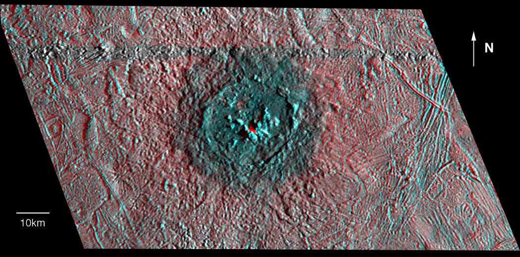
This three dimensional effect is created by superimposing images of Jupiter's moon, Europa, which were taken from two slightly different perspectives. When viewed through red (left eye) and blue (right eye) filters, the product, an anaglyph, shows variations in height of surface features.
The anaglyph shows Pwyll crater on Jupiter's icy satellite Europa. The crater is about 16 miles (26 kilometers) across and has a central peak which rises almost 2,000 feet (about 600 meters) above the crater floor. The heavily degraded rim reaches a height of only 980 feet (300 meters). A central peak that is higher than the crater rim is unusual among other craters in the Solar System. A continuous ejecta blanket around the impact structure rises above the surrounding landscape and is at about the same topographic level as the crater floor. The Pwyll impact appears to have occurred on a northwest to southeast (upper left to lower right) trending slope.
North is to the top of the picture. Pwyll is located at about 25 degrees south latitude and 271 degrees west longitude. The stereo perspective combines high resolution images obtained from two different camera positions. Such a three dimensional model is similar to the three dimensional scenes our brains construct from images seen by the left and right eyes. The picture is based on such a computer generated model using images taken by the Solid State Imaging (SSI) system on NASA's Galileo spacecraft on two separate orbits. The grey band running completely across the image just north of Pwyllis where a gap in the data prevented three dimensional modelling. The images of Pwyll were taken from different viewing geometries on Feb. 20, 1997 and Dec. 16, 1997 at ranges of 8,200 miles (13,200 kilometers) and 8,400 miles (13,500 kilometers).